
There are literally hundreds of old mines dotted around the Flinders Ranges yet most were dismal failures.
One of the more profitable ones is on Depot Springs Station. Paull’s Consolidated Copper MIne operated up till the 1920s.
It was a surprisingly large mine site in comparison with other ruins in the area.

There’s still lots of old relics around and pits which show the extent of the mining.
Boilers, rock breakers and crushers all stand on the side of the hill which would have been a hive of activity at the beginning of the last century.


A nearby grave site marks what seems to be the last resting place of one miner.

Details carved in a rock give little insight into the story behind the grave.
]]>
It’s the fourth largest copper deposit in the world and the largest known uranium find to date. Large amounts of copper, uranium, gold and silver are mined here every year.
The Olympic Dam mine reportedly uses a staggering 35 million litres of artesian water each day, making it the largest industrial user of underground water in the southern hemisphere.
This is having a negative effect on the flora and fauna of nearby mound springs, which are drying out as a result of the water draw-down rate.

Generally it’s believed the massive water use impacts on wildlife across the region, affecting plants trees, fish, birds and other small water-living creatures that rely on artesian water sources.
On the other side of the coin the mine supports many miners and their families and the nearby town of Roxby Downs. It obviously generates much income for the region and the state.
Olympic Dam is set for an even bigger expansion of its mining operation in the near future.
]]>
Train Wreck.
The Leigh Creek Coal train was derailed over the weekend as it headed, fully-laden with coal, to the power station at Port Augusta.
I got a gig shooting some pictures for the Channel 9 News in Adelaide – a bit like old times, in a roundabout way.

The chaps crewing the train were pretty lucky. The derailment occurred behind the locomotives.

The three kilometre train was broken into three segments. The main damage involved 22 cars which were scattered and concertina-ed.
The train travels at about 80 kilometres an hour so when disaster strikes the combined weight of all the cars and coal is enormous.
The momentum would have been very hard to arrest, hence the incredible pile up.

I couldn’t resist a landscape photo – it puts the whole thing into perspective
]]>
Many thanks to those people – and there were a lot – who put in submissions to the relevant departments regarding mining on the Arkaroola Wilderness Sanctuary.
I believe about 700 submissions in all were received and I think a majority of them were against any sort of mining in the area.
However it’s early days yet. It will be interesting to see what comes out of it all.
Strange twist though…the Environment Minister announced, as submissions on Arkaroola’s future were closing, a new protected area, with no mining , on the Nullabor Plain. Figure that out.
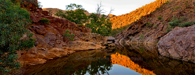
To things more sublime – I posted a shot of Arkaroola Waterhole back in June last year link.
This was taken the same morning but using a different lens. The wide angle panorama changed the colours a bit and washed out the sky although I’m still happy with the outcome. I’d be interested to hear what others think.
]]>
It doesn’t take much effort to type out a few words and email them to one or both of these two gentleman
[email protected] or [email protected]
to register your view regarding the prospect of uranium mining taking place in the Arkaroola Wilderness Sanctuary.
The last day to is next Friday, January 29.
My submission went in yesterday – one of the reason why I’ve been a bit slack with postings here in recent times.
Here’s what I’ve said:
I am writing to you in regard to the proposed rezoning of the northern Flinders Ranges as outlined in the joint publication by your department under the title “Seeking a Balance.”
Before outlining the proposals I suggest, I think there are a number of issues which need to be addressed.
1. There are no detailed maps of the proposed changes. The management zone map appears to split East Mt. Painter Gorge laterally into a protected habitat on one side while the other side of the gorge is open to exploration and mining. This seems to have opened up the most likely access route into Mt Gee to a mining operation while paying lip service to authorised conservation methods.
2. There is no information from any source, including the “Seeking a Balance” document, which explains how uranium mining on Mt Gee might be carried out. It is therefore virtually impossible to determine what would be the real impact on the flora and fauna of the region without this detail.
3. The cultural values of significance to the Adnyamathanha people seem to have been completely ignored, particularly when there are some sites on Arkaroola which are relatively close to the proposed Mt Gee mining operation.
4. The document only looks at the Arkaroola Wilderness Sanctuary and its immediate neighbours (i.e. a quarter of the area supposedly addressed in the document) and ignores other areas of importance in the northern Flinders Ranges.
5. The document makes no comparison between Arkaroola and the neighboring Vulkathunha Gammon Ranges National Park where no mining is allowed. Many of the same values that made the proclamation of the Vulkathunha Gammon Ranges National park can be found on Arkaroola.
6. Sillers Lookout, known by just about every South Australian because of its spectacular views, and a centre piece of Arkaroola, is in Access Zone 2a, which technically means that it could be mined if an economic orebody was found underneath. Why is this not labelled as Access Zone 1?
With its unique geology and landforms, lack of weeds, intact plant communities and position as the northernmost protected area in the Flinders Ranges, the Arkaroola Wilderness Sanctuary is a critical part of the northern Flinders corridor.
The “Seeking a Balance” framework fails to deliver appropriate levels of protection for individual species and ignores the Department of Environment & Heritage’s own policies that advocate landscape conservation, regardless of tenure.
Some of the wildest, most elevated, least modified and most bio-diverse landscapes in the Flinders Ranges occur in and around the Arkaroola Wilderness Sanctuary. Five properties all destocked and managed for conservation create a corridor that stretches from Lake Frome to Warraweena. The Arkaroola Wilderness Sanctuary, the Vulkathunha Gammon Ranges National Park, Nantawarinna indigenous protection area, Pinda Springs and Warraweena Private Conservation park provide refuge for rare and threatened species, some of which are found nowhere else in the world. These areas also provide a corridor that enables colonies of rock wallabies (and other species) to intermingle as required under Dept Environment & Heritage NatureLinks policy.
Today, Arkaroola has a greater concentration of rock wallaby colonies than any other property in the northern Flinders Ranges. However, under proposed new zoning there is no uniform protection for known rock wallaby habitats across Arkaroola. No connectivity has been provided between colonies along Arkaroola Creek where most of the sanctuary’s permanent waterways are found, and colonies to the north and south within the Sanctuary.
Another issue is the future of the spidery wattle, Acacia araneosa which is found along the border between Arkaroola and the Vulkathunha Gammon Ranges National Park. Its distribution covers less than 10 square kilometres and it is found there and nowhere else in the world. Spidery wattle is struggling to survive. With the proposed new management framework, most of the population occurs in Access Zone 3 where standard exploration and mining conditions apply.
It is therefore my strong view that the entire area of the Arkaroola Wilderness Sanctuary should remain a Class A Environmental Zone and that the zoning should in fact be strengthened to protect the area from mining operations in the future. Or if the Proposal for Zoning is accepted, then all of the Arkaroola Wilderness Sanctuary is made Zone 1: No mining access.
Little is known about the hydrology of the Flinders Ranges. The relationship of aquafiers, their movement at the surface as springs and seepages and their recharge rates are poorly understood.
In a submission to the Australian government in 2007, Marathon Resources advised that it would require 5.5 million litres per day for processing activities should a mining application be approved in the future. This extraction rate would continue for a protracted mine life of 13 years.
The company would seek water from a variety of sources on the plains and in the ranges. Any approval to extract this measure of water from the region would contravene the government’s own targets and prescriptions around the sustainable use of water resources. It would appear that this requirement for mining would have a critical effect on eco systems already under stress.
The “Keeping a Balance” document glosses over the tourism perspective, which I believe has a great significance in the region. Many individuals, businesses and tourism operators rely on the flow of people travelling to and from the Arkaroola region. No account of the many millions of dollars that is generated to the central and northern Flinders Ranges has been taken into consideration.
Tourism values appear to have been based on the Landscape Value Survey which concludes that the area has only moderate scenic value.
The methodology of the Landscape Value Survey is flawed and open to criticism on a number of levels, particularly when this is such a subjective subject. The number of visitors to the region over many, many years does not support the outcomes of the survey, although it does conclude that no mining should take place from a tourism point of view on the Arkaroola Wilderness Sanctuary.
In regard to rehabilitation if mining were to go ahead in the sanctuary, it is my belief as much as eight decades would be needed to restore the land fully. That on top of the projected mining operation of 13 years.
This is based on the scars from exploration tracks already on the Arkaroola landscape that have been there since the mid 1900s. This is an arid land where vegetation does not bounce back quickly.
In conclusion, I believe there are so many issues involved in the debate about mining in the Arkaroola Wilderness Sanctuary that the damage to the region could not be fully understood. It would therefore be highly dangerous to do anything but ban any form of mining in the Arkaroola Wilderness Sanctuary.
Marathon Resources already has an appalling record during the exploration stage and have proven still to have no real understanding of the delicate nature of the area in which they propose to mine.
The decision to mine on Arkaroola would be based on the premise that the deposit there was so big that to ignore it would be folly. It is my understanding that the interest in mining there is based on in formation supplied by Marathon Resources.
There is also available now information which questions the viability of uranium mining at Mt Gee. This includes:
* The amount of ore that can actually be extracted strongly depends on the mining technique that is employed.
* Underground mining would significantly reduce the amount of extractable ore.
* The ore does not occur in regular, easily recognizable bodies.This makes it virtually impossible to predict where to excavate.
* The ore occurs in strongly altered, often extremely friable and highly heterogeneous breccia (rock consisting of angular pieces cemented together), which would pose significant difficulties to underground mining. The problem is aggravated by the presence of Mt. Gee-type veins and breccia, which consist of very hard quartz-haematite breccia with large voids.
* The ore underneath Mt. Gee occurs at a relative shallow depth, especially below the western slope of Mt. Gee, where the ore-bearing zone breaches the surface. Considering the nature of the ore and host rock, near-surface underground mining would be a serious engineering challenge.
* It seems unlikely that a major part of the uranium of the main deposit underneath Mt. Gee could be extracted by underground mining. This then means there is a real danger open cut mining would be the next step.
* It is therefore doubtful whether the challenges to underground mining would make mining of the smaller satellite deposits viable.
These facts must be taken into account in the final analysis.
]]>
Here’s a local South Australian icon that’s known to people call over the country and indeed the world.
I can only use my photography to make the point that it would be crazy to wreck this amazing country with mining.
The time available for making public submissions on the issue has been moved back to the end of January.
More importantly though Arkaroola has received advice the consultation process requires submissions to specifically address the management policies and zoning framework proposed in Government’s ‘Seeking a Balance’ document.
It’s outrageous if the Government should attempt to ignore submissions that simply say I don’t want to see any mining on the wilderness sanctuary.
If you want a better understanding of the situation click on UnkownsSA
If you want to make a submission, you can get some guidelines from Save Arkaroola
If you don’t think its a serious situation, Marathon Mines today notified of their intention to start low impact exploration on Arkaroola again in the near future.
The photo is Split Rock Lookout on the Ridgetop Track – massive granite outcrops in the most rugged of Arkaroola’s central and oldest country.
From here, if I’m right you would be able to see all the trucks, all the mining equipment, the air shafts, the dust and the rubble should it go ahead.
]]>
I posted some photographs about uranium mining in one of my favorite locations in the Flinders Ranges back on Sunday September 20.
To Beautiful to Ruin.
A statement by the South Australian Premier a couple of days ago indicates that his government will only regulate mining in this fantastic area, not ban it.
Being what it is, political speak is a bit hard to understand but phrases like “preserve areas of local heritage and scenic beauty:…..”low impact exploration” and standard exploration and mining access, all in the one statement don’t add up to much in the way of protection.
“The framework clearly provides for ongoing access to areas of high mineral prospectivity” doesn’t mean much long term protection for the Arkaroola Wilderness Sanctuary and in particular Mt Gee, seen here with some of the tracks and tanks already quite visible.
Arkaroola, and indeed all of the northern Flinders Ranges is one of Australia’s most rugged tourist, cultural and heritage regions. If they’ll allow this place to be carved up then it’s likely to happen anywhere else too, unless public opinion for a mining ban is strong.
]]>
Mining a century or more ago was not for the faint-hearted. There was no fly-in-fly-out or roatating shifts..
What was once the Assay office at the Sliding Rock copper mine stands in ruins more than 130 years after it closed for business.
A whole community complete with hotel, butcher shop and family homes sprung up here when copper was discovered in 1870.
The mining work was substantial until water flooded the mines seven years later and the town was doomed.

Sliding Rock is on Warraweena conservations park east of Beltana in the northern Flinders Ranges. It’s well worth a look at, as even today much of the mine and the town are still there.
The fireplace in the hotel still stands

Ruins of the Sliding Rock Hotel not far from the mine shaft and the copper smelter.
]]>
There are three companies here in the Outback trying to harness the energy far below the earth’s surface to produce electricity for domestic and industrial use.
Apart from the one here at Paralana there’s another at Innamincka and a third one the western side of the Flinders Ranges.
This rig, which came from Dubai, had to be transported by 75 trucks from Port Pirie.
Once the drilling is completed the rig will be dismantled and removed and the second stage of the project begins.
There was a 30 second exposure on this shot which made the fast moving clouds look a little surreal.
]]>
Mother Nature was indeed kind to me the evening I managed to get this image.
I spent several days at the hot rock drilling site near Paralana, after getting permission from one of the venture partners, Beach Petroleum, to take late afternoon, dusk and night shots.
The first night I worked out that this was probably the best angle but four very strong lights which lit up the entire working platform of the rig just ruined all the shots I took.
On the last evening the crew kindly agreed to cut the main lights for ten minutes but in fact had them off for the entire time I was shooting. What a bonus and Thank You.
The sunset then went to work and turned on a display that was hard to believe. What a symbol of harnessing natural clean energy.
]]>
An amazing spectacle to come across unexpectedly in the dead of night in remote Outback South Australia.
It’s a giant 54 metre high drill rig that will eventually put a shaft about four kilometres into the earth’s crust.
It’s out near Lake Frome. A vast sum of money is being invested in a project to produce electricity generated by water that’s super-heated from hot rock the drillers hope to find way down there.
If successful, it will be a vast resource of environmentally friendly, renewable energy.
While the drilling goes on 24 hours a day, it’s a landmark that can be seen from afar, night or day.
Sorry about the ‘awful’ heading
]]>
This is Mt Gee on the Arkaroola Wilderness Sanctuary in the northern Flinders Ranges.
The South Australian Government has announced that in less than a month it intends to renew the exploration license of a company that wants to mine uranium here.
That company held an exploration license which they lost because, among a number of incidents, they illegally buried 23,000 bags of low level radioactive material and general waste. They also illegally buried another twenty 200 litre drums of similar material in the beautiful Yudnamutana Gorge a couple of kilometres from the Paralana Hot Springs.
It is now feared that when their exploration lease is renewed, they’ll be permitted to resume high level exploration and expect to go on to mining uranium.
The company won’t be allowed to mine uranium by open-cut, the only alternative would be by tunneling to Mt Gee.
Whichever way the uranium is mined, it would produce an enormous amount of waste and much would be radioactive. Vast amounts of earth and rock from the tunneling and mining would be dumped and stored in the surrounding countryside. Giant air vents and escape shafts would need to be installed across the mountains with tracks to maintain them.
Rehabilitation will be required, but in arid mountain ranges with irregular, low rainfall, rehabilitation does not guarantee regeneration. Past experience shows this can take up to 80 years.
The company has already advised Federal authorities that to run the mine and process the uranium will require 2 to 2.5 gigalitres of water per year – an average of 6 million litres of water per day!
Where’s that coming from and at what cost to the plants and animals of this arid environment?
Mining in the Outback is a fact of life and there’s a lot of well managed operations in this region which produce much needed resources and provide employment for thousands of families. That’s not the issue here.
Hopefully people who have visited this country over the years will understand the significance of what mining on Arkaroola would do.
There’s already one avenue to register your opposition to further exploration and mining on Arkaroola through a Wilderness Society peitition. It’s pretty easy to do and you don’t have to join anything – just register your thoughts which will get passed on to the decision makers.
So far more than 2100 people have signed the internet petition and even though the number is growing, it’s early days yet.
Here’s the site Wilderness Society petition
If you want to find out more about the uranium mining issue on Arkaroola go to mining at Arkaroola..
]]>
Just on three kilometres in length the Leigh Creek Coal Train is quite a sight by anyone’s standards.
It’s the longest train in Australia pulled by locomotives at one end. (A coal train with locomotives front and back operates in Queensland and is longer). Three locomotives coupled together pull around 160 wagons laden with coal 250 kilometres to the Port Augusta power station every day. (Google Maps – Leigh Creek)
The Mine has been operating since 1943 so an enormous amount of brown coal has been moved south since then.
The train travels at no more than 80 kilometres an hour and because of the temperatures in summer does the round trip at night because the intense heat of the day sometimes buckles the tracks.
]]>
The mountain in the middle ground of this photograph is Mt Gee on the Arkaroola Wilderness Sanctuary. Mt Gee is the target for a mining company that is planning to extract a deposit of uranium far beneath the mountain.
In October two years ago the Sprigg family, who’ve operated the wilderness sanctuary for a couple of generations approached me to produce a series of photographs which would show the beauty of the country, particularly from Coulthards to Sillers Lookout.
They understandably don’t want uranium mined at Mt Gee right in the heart of one of the most beautiful places in Australia.
A fully fledged mining operation there would have a devastating effect on the land for 50 years or more.
Even though mining hasn’t started yet, the company, Marathon has already run foul of the standards set down by the state government.
Over the last two years I’ve made a number of visits to Arkaroola and from time to time I’ll be posting the photos I have taken.
If you want to find out more about the uranium mining issue on Arkaroola go to mining at Arkaroola.
Apart from the uranium, Mt Gee is unique because of the variety of quartz crystals formed there several hundred million years ago.
The third highest peak in the Flinders Ranges, Mt McKinlay-Wayanha sits in the background. Google Maps – Arkaroola Village SA)
]]>