
It doesn’t take much effort to type out a few words and email them to one or both of these two gentleman
[email protected] or [email protected]
to register your view regarding the prospect of uranium mining taking place in the Arkaroola Wilderness Sanctuary.
The last day to is next Friday, January 29.
My submission went in yesterday – one of the reason why I’ve been a bit slack with postings here in recent times.
Here’s what I’ve said:
I am writing to you in regard to the proposed rezoning of the northern Flinders Ranges as outlined in the joint publication by your department under the title “Seeking a Balance.”
Before outlining the proposals I suggest, I think there are a number of issues which need to be addressed.
1. There are no detailed maps of the proposed changes. The management zone map appears to split East Mt. Painter Gorge laterally into a protected habitat on one side while the other side of the gorge is open to exploration and mining. This seems to have opened up the most likely access route into Mt Gee to a mining operation while paying lip service to authorised conservation methods.
2. There is no information from any source, including the “Seeking a Balance” document, which explains how uranium mining on Mt Gee might be carried out. It is therefore virtually impossible to determine what would be the real impact on the flora and fauna of the region without this detail.
3. The cultural values of significance to the Adnyamathanha people seem to have been completely ignored, particularly when there are some sites on Arkaroola which are relatively close to the proposed Mt Gee mining operation.
4. The document only looks at the Arkaroola Wilderness Sanctuary and its immediate neighbours (i.e. a quarter of the area supposedly addressed in the document) and ignores other areas of importance in the northern Flinders Ranges.
5. The document makes no comparison between Arkaroola and the neighboring Vulkathunha Gammon Ranges National Park where no mining is allowed. Many of the same values that made the proclamation of the Vulkathunha Gammon Ranges National park can be found on Arkaroola.
6. Sillers Lookout, known by just about every South Australian because of its spectacular views, and a centre piece of Arkaroola, is in Access Zone 2a, which technically means that it could be mined if an economic orebody was found underneath. Why is this not labelled as Access Zone 1?
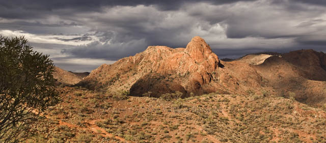
With its unique geology and landforms, lack of weeds, intact plant communities and position as the northernmost protected area in the Flinders Ranges, the Arkaroola Wilderness Sanctuary is a critical part of the northern Flinders corridor.
The “Seeking a Balance” framework fails to deliver appropriate levels of protection for individual species and ignores the Department of Environment & Heritage’s own policies that advocate landscape conservation, regardless of tenure.
Some of the wildest, most elevated, least modified and most bio-diverse landscapes in the Flinders Ranges occur in and around the Arkaroola Wilderness Sanctuary. Five properties all destocked and managed for conservation create a corridor that stretches from Lake Frome to Warraweena. The Arkaroola Wilderness Sanctuary, the Vulkathunha Gammon Ranges National Park, Nantawarinna indigenous protection area, Pinda Springs and Warraweena Private Conservation park provide refuge for rare and threatened species, some of which are found nowhere else in the world. These areas also provide a corridor that enables colonies of rock wallabies (and other species) to intermingle as required under Dept Environment & Heritage NatureLinks policy.
Today, Arkaroola has a greater concentration of rock wallaby colonies than any other property in the northern Flinders Ranges. However, under proposed new zoning there is no uniform protection for known rock wallaby habitats across Arkaroola. No connectivity has been provided between colonies along Arkaroola Creek where most of the sanctuary’s permanent waterways are found, and colonies to the north and south within the Sanctuary.
Another issue is the future of the spidery wattle, Acacia araneosa which is found along the border between Arkaroola and the Vulkathunha Gammon Ranges National Park. Its distribution covers less than 10 square kilometres and it is found there and nowhere else in the world. Spidery wattle is struggling to survive. With the proposed new management framework, most of the population occurs in Access Zone 3 where standard exploration and mining conditions apply.
It is therefore my strong view that the entire area of the Arkaroola Wilderness Sanctuary should remain a Class A Environmental Zone and that the zoning should in fact be strengthened to protect the area from mining operations in the future. Or if the Proposal for Zoning is accepted, then all of the Arkaroola Wilderness Sanctuary is made Zone 1: No mining access.
Little is known about the hydrology of the Flinders Ranges. The relationship of aquafiers, their movement at the surface as springs and seepages and their recharge rates are poorly understood.
In a submission to the Australian government in 2007, Marathon Resources advised that it would require 5.5 million litres per day for processing activities should a mining application be approved in the future. This extraction rate would continue for a protracted mine life of 13 years.
The company would seek water from a variety of sources on the plains and in the ranges. Any approval to extract this measure of water from the region would contravene the government’s own targets and prescriptions around the sustainable use of water resources. It would appear that this requirement for mining would have a critical effect on eco systems already under stress.
The “Keeping a Balance” document glosses over the tourism perspective, which I believe has a great significance in the region. Many individuals, businesses and tourism operators rely on the flow of people travelling to and from the Arkaroola region. No account of the many millions of dollars that is generated to the central and northern Flinders Ranges has been taken into consideration.
Tourism values appear to have been based on the Landscape Value Survey which concludes that the area has only moderate scenic value.
The methodology of the Landscape Value Survey is flawed and open to criticism on a number of levels, particularly when this is such a subjective subject. The number of visitors to the region over many, many years does not support the outcomes of the survey, although it does conclude that no mining should take place from a tourism point of view on the Arkaroola Wilderness Sanctuary.
In regard to rehabilitation if mining were to go ahead in the sanctuary, it is my belief as much as eight decades would be needed to restore the land fully. That on top of the projected mining operation of 13 years.
This is based on the scars from exploration tracks already on the Arkaroola landscape that have been there since the mid 1900s. This is an arid land where vegetation does not bounce back quickly.
In conclusion, I believe there are so many issues involved in the debate about mining in the Arkaroola Wilderness Sanctuary that the damage to the region could not be fully understood. It would therefore be highly dangerous to do anything but ban any form of mining in the Arkaroola Wilderness Sanctuary.
Marathon Resources already has an appalling record during the exploration stage and have proven still to have no real understanding of the delicate nature of the area in which they propose to mine.
The decision to mine on Arkaroola would be based on the premise that the deposit there was so big that to ignore it would be folly. It is my understanding that the interest in mining there is based on in formation supplied by Marathon Resources.
There is also available now information which questions the viability of uranium mining at Mt Gee. This includes:
* The amount of ore that can actually be extracted strongly depends on the mining technique that is employed.
* Underground mining would significantly reduce the amount of extractable ore.
* The ore does not occur in regular, easily recognizable bodies.This makes it virtually impossible to predict where to excavate.
* The ore occurs in strongly altered, often extremely friable and highly heterogeneous breccia (rock consisting of angular pieces cemented together), which would pose significant difficulties to underground mining. The problem is aggravated by the presence of Mt. Gee-type veins and breccia, which consist of very hard quartz-haematite breccia with large voids.
* The ore underneath Mt. Gee occurs at a relative shallow depth, especially below the western slope of Mt. Gee, where the ore-bearing zone breaches the surface. Considering the nature of the ore and host rock, near-surface underground mining would be a serious engineering challenge.
* It seems unlikely that a major part of the uranium of the main deposit underneath Mt. Gee could be extracted by underground mining. This then means there is a real danger open cut mining would be the next step.
* It is therefore doubtful whether the challenges to underground mining would make mining of the smaller satellite deposits viable.
These facts must be taken into account in the final analysis.
I am very impressed by your submission and have written to the 2 people mentioned to register my vehement opposition to the proposed rezoning. I hope that many others have done the same.
It would be a tragedy to have Arkaroola mined – but the thing that puzzles me is how minimg ould be contemplated when so much water is needed for the process in a place where water is so scarce.